Sold by

L'Art de la Memòria✓Verified
Antigüedades sobre papel. Cartografía antigua. Catalonia. Geography
Sant Andreu de Llavaneres, España
Art & Paintings · 19th Century
ES·EN·PT·DE·FR
Product price
299.5 €
Estimate shipping
Where do we ship?
Also available for free pickup in Sant Andreu de Llavaneres
Ask about shipping, condition, history, or any questions.
Suggest a price. Sellers typically respond within 24 hours.
No commitment — you only pay if you accept the final agreement.
299,5 €
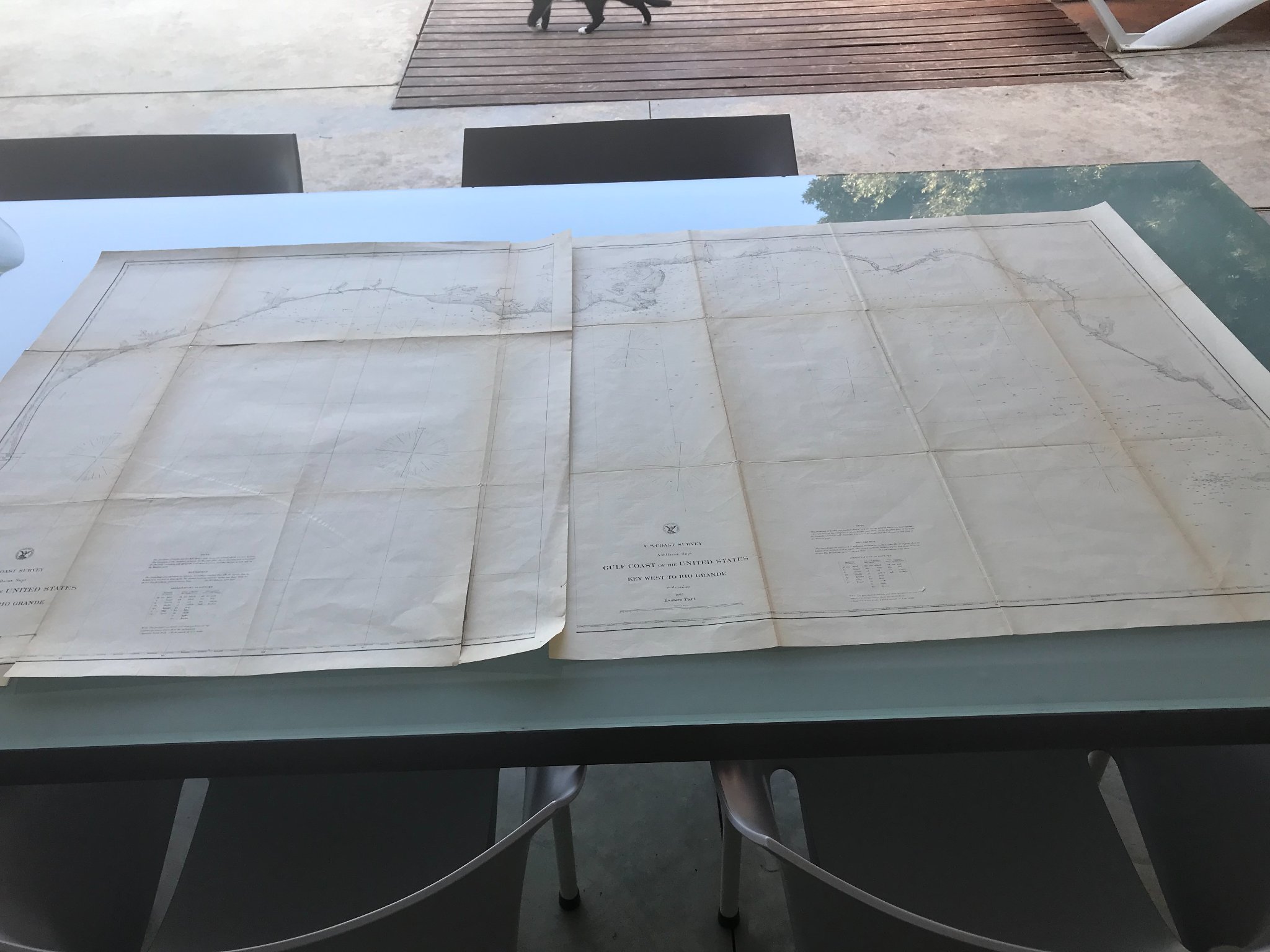
Historical map from 1863 representing the Gulf Coast of the United States, from Key West to Rio Grande. Created by BACHE, this map offers precise geographical details of the time. Printed on paper, it shows coastal features and navigation of the mid-19th century. The cartography includes details of the coastline and nautical landmarks. Well preserved, with minor signs of wear appropriate for its age.
Work Description
Title: Chart of the Gulf Coast of the United States: from Key West to Rio Grande [In 2 sheets: Western Part and Eastern Part].
Author: U.S. Coast Survey (Under the direction of A.D. Bache).
Publication Date: 1863.
Place of Printing: Washington, D.C.
Historical Context:
This imposing nautical chart was produced during the Civil War (American Civil War). Its creation had not only civil navigation purposes but was also a fundamental strategic tool for the Union Navy in executing the "Anaconda Plan," the naval blockade aimed at suffocating the trade of the Confederate States.
Technical and Cartographic Details:
Geographic Scope: The map covers the entire northern coastline of the Gulf of Mexico, from the keys of Key West (Florida) to the mouth of the Rio Grande (border with Mexico/Texas).
Scale: 1:600,000.
Content: It represents with extreme precision the marine depths (soundings), the coastline, the entrances of the bays, sandbanks, and the location of lighthouses. The coastal topography includes details about marshes, vegetation, and the early urban settlements of the area.
Composition: It is divided into two large sections designed to be assembled or consulted independently: the Eastern Part (from Key West to the mouth of the Mississippi) and the Western Part (from the Mississippi to Texas).
Collector's Value:
It is considered one of the most scientific and detailed representations of the 19th century of this region. As an official printing of the U.S. Coast Survey, it stands out for the sobriety and elegance of its copper engraving, typical of state cartography in the U.S. at the time.
Approximate Dimensions:
Individual Sheet: 60 x 95 cm.
Assembled Set: 120 x 95 cm (variable depending on margins).
Suggested uses
Exhibition in a historical map gallery
Decoration in a nautical-themed office
Reference for historical studies
Private collection of antique cartography
Sold by
L'Art de la Memòria✓Verified
Antigüedades sobre papel. Cartografía antigua. Catalonia. Geography
Sant Andreu de Llavaneres, España
Sant Andreu de Llavaneres, España
Exact shipping cost depends on the destination and dimensions of the piece. Contact the seller for a quote.
Shipping cost is defined by the seller based on the destination and characteristics of the piece. They will inform you after confirming the purchase.
The seller coordinates shipping insurance. We recommend confirming coverage before shipping.
Delivery time depends on origin and destination. The seller will give you an estimate after purchase.
Each seller picks one of Antiga's four return policies (14-day returns, exchanges only, defects only, or no returns). The policy for this piece appears next to the price.
Verified pieces
Every seller and piece is reviewed by our team.
Contact & negotiate
Talk directly with the seller with no commitment.
Coordinated payment
We manage payment for the safety of both parties.
Receive your piece
Coordinated shipping with tracking included.
Art & Paintings
18th Century · Italia
Paper
L'Art de la Memòria · Sant Andreu de Llavaneres · 1 week ago
365 €
Art & Paintings
18th Century · Italia
Paper, ink
L'Art de la Memòria · Sant Andreu de Llavaneres · 1 week ago
465 €