Sold by

L'Art de la Memòria✓Verified
Antigüedades sobre papel. Cartografía antigua. Catalonia. Geography
Sant Andreu de Llavaneres, España
This piece has been sold. Discover similar pieces.
Art & Paintings · First half of the 20th Century
ES·EN·PT·DE·FR
Product price
130 €
Estimate shipping
Where do we ship?
Also available for free pickup in Sant Andreu de Llavaneres
Online payment coming soon. For now, contact the seller directly.
Ask about shipping, condition, history, or any questions.
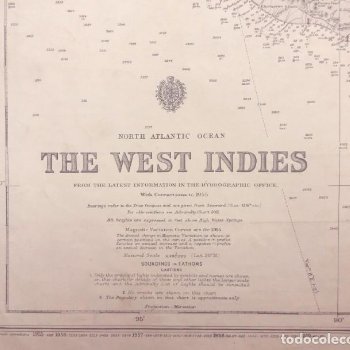
Nautical chart of the West Indies, produced in 1955 from the original edition of 1903. Published by the Admiralty, this chart shows geographical and maritime details of the region. Printed on paper, it presents hydrographic information relevant for navigation of the time. The chart is in good condition with minor wear appropriate for its age. It is a notable example of 20th-century nautical cartography.
This nautical chart is a highly precise technical document published by the British Admiralty. Although the original plate and base triangulation date back to 1903, this specific copy is an updated edition with corrections up to 1955, a key period for commercial navigation after World War II.
Physical Details and Measurements
Editor: Hydrographic Office of the Royal Navy, under the authority of the Hydrographer of the Admiralty.
Dimensions: Standard "Full Size" format, approximately 104 x 71 cm (41 x 28 inches).
Material: High-weight paper, designed to withstand constant use on the bridge.
Scale: Generally coastal navigation or approach scales, depending on the specific section of the Antilles it represents.
Content Description
The chart covers strategic areas of the West Indies (the Caribbean), including:
Soundings and Depths: Updated depth data, crucial for deeper draft vessels that began operating in the 1950s.
Coastlines: Details reefs, sandbanks, and underwater hazards that were constant in the Caribbean region.
Navigational Aids: Exact position of lighthouses, buoys, and radio aids, with their light characteristics updated to 1955.
Manual Corrections: It is common for these charts to have annotations in red ink or stamps in the lower left corner detailing minor corrections (Small Corrections) made year after year.
Suggested uses
Nautical office decoration
Exhibition in maritime museums
Reference for historical studies
Thematic interior decoration
Sold by
L'Art de la Memòria✓Verified
Antigüedades sobre papel. Cartografía antigua. Catalonia. Geography
Sant Andreu de Llavaneres, España
Sant Andreu de Llavaneres, España
Exact shipping cost depends on the destination and dimensions of the piece. Contact the seller for a quote.
Shipping cost is defined by the seller based on the destination and characteristics of the piece. They will inform you after confirming the purchase.
The seller coordinates shipping insurance. We recommend confirming coverage before shipping.
Delivery time depends on origin and destination. The seller will give you an estimate after purchase.
Each seller picks one of Antiga's four return policies (14-day returns, exchanges only, defects only, or no returns). The policy for this piece appears next to the price.
Verified pieces
Every seller and piece is reviewed by our team.
Contact & negotiate
Talk directly with the seller with no commitment.
Coordinated payment
We manage payment for the safety of both parties.
Receive your piece
Coordinated shipping with tracking included.
Art & Paintings
18th Century · Italia
Paper
L'Art de la Memòria · Sant Andreu de Llavaneres · 1 week ago
365 €
Art & Paintings
18th Century · Italia
Paper, ink
L'Art de la Memòria · Sant Andreu de Llavaneres · 1 week ago
465 €