Sold by
L'Art De La MemòRia✓Verified
Antigüedades sobre papel. Cartografía antigua. Catalonia. Geography
Sant Andreu de Llavaneres, España
Art & Paintings · 17th Century
ES·EN·PT·DE·FR
Product price
881 €
Estimate shipping
Where do we ship?
Also available for free pickup in Sant Andreu de Llavaneres
Ask about shipping, condition, history, or any questions.
Suggest a price. Sellers typically respond within 24 hours.
881 €
No commitment — you only pay if you accept the final agreement.
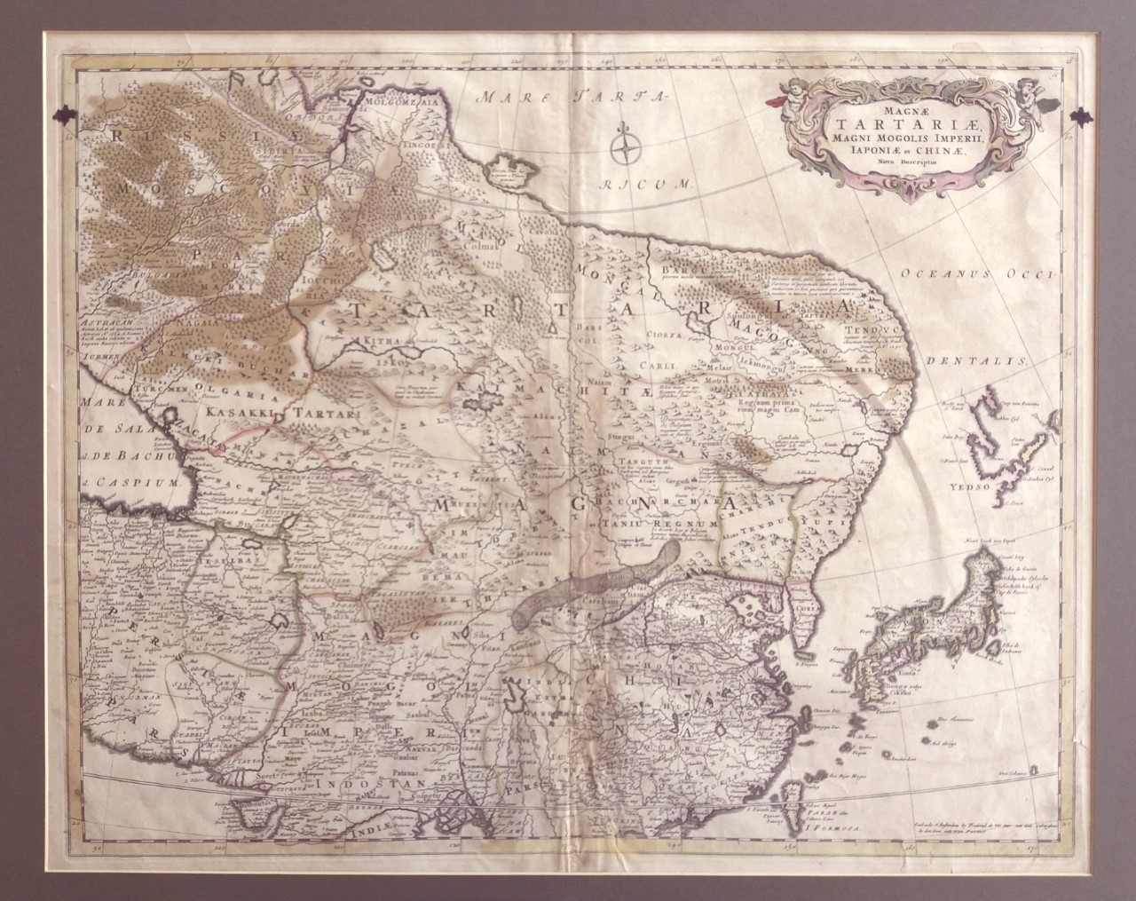
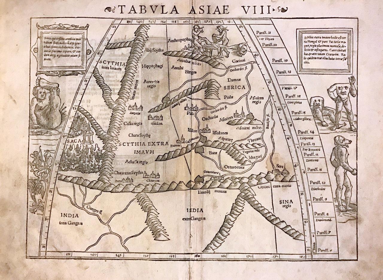
This copper-engraved map, titled 'Magnae Tartariae, Magni Mogolis, Imperii Iaponiae et Chinae Nova Descriptio', was created by Frederick de Wit in Amsterdam around 1680. It represents the northeast of Asia, from the island of Formosa to the north of the Arctic Circle. The representation includes 'Great Tartary', the Mughal Empire, China, and Japan, reflecting European knowledge of the 17th century. The map shows the Great Wall and multiple cities in China and northern India. Decorative elements include finely engraved mountains and trees. The topography is speculative, with coastlines and geographical features that are not precise. The condition is good, with wear consistent with its age. Frederick de Wit, one of the most prominent cartographers of the Dutch Golden Age, produced several influential maps of East and Southeast Asia during the 17th century. His most iconic work for this region is the Tabula Indiae Orientalis (c. 1662–1680), which reflects the height of Dutch maritime power and geographical knowledge. Key Features of the Map Geographical Scope: The map covers the vast region from the southeastern coast of Persia and India to Japan, the Philippines, and the northern coast of Australia (labeled as Hollandia Nova). Colonial Trade Routes: It highlights the strategic interests of the Dutch East India Company (VOC), showing major trading hubs like Batavia (modern-day Jakarta) and the island of Formosa (Taiwan). Decorative Cartouche: De Wit's maps are famous for their artistic flair. This one typically features a title cartouche adorned with figures of Asian merchants, turbaned warriors, and exotic animals. Cartographic Anomalies: Common for the time, it includes mythical elements like Lake Chiamay in central China, believed to be the source of five major Asian rivers. It also often depicts New Guinea as being joined to ... image: 45 x 56 cm (or 18 x 22 inches) sheet: 52 x 62 cm
Suggested uses
Exhibition in an antique map gallery
Decoration in a private library
Centerpiece in a historical cartography collection
Educational use in academic institutions
Sold by
L'Art De La MemòRia✓Verified
Antigüedades sobre papel. Cartografía antigua. Catalonia. Geography
Sant Andreu de Llavaneres, España
Sant Andreu de Llavaneres, España
Exact shipping cost depends on the destination and dimensions of the piece. Contact the seller for a quote.
Shipping cost is defined by the seller based on the destination and characteristics of the piece. They will inform you after confirming the purchase.
The seller coordinates shipping insurance. We recommend confirming coverage before shipping.
Delivery time depends on origin and destination. The seller will give you an estimate after purchase.
Each seller picks one of Antiga's four return policies (14-day returns, exchanges only, defects only, or no returns). The policy for this piece appears next to the price.
Verified pieces
Every seller and piece is reviewed by our team.
Contact & negotiate
Talk directly with the seller with no commitment.
Coordinated payment
We manage payment for the safety of both parties.
Receive your piece
Coordinated shipping with tracking included.
Art & Paintings
16th Century
Papel
L'Art de la Memòria · Sant Andreu de Llavaneres · 4 days ago
750 €
Art & Paintings
18th Century · Francia
Paper
L'Art de la Memòria · Sant Andreu de Llavaneres · 4 days ago
140 €17th Century · Spain (Europe)
Oil on panel
Antique Arts · Madrid · 4 days ago